 Expedition Navigation Software
  1 of 1
- Herman_NL
- Expert
 Offline
 - From: The Netherlands
- Registered: 2/05/2023
- Posts: 16
Polar projection raster image import failed
Hi,
I would like to import a polar projection with MSLP data from this source =13px
After conversion into a picture I tried importing it into Exp as weather raster image. Geo-referenced top left (10n 40e) and bottom right (10n 140w) and marked the chart as "polar stereographic".
There is also half a polar projection with MSLP data available here =13px
Both return an error "unable to import".
Any suggestions are very welcome!
Herman
- Ernie M
- Moderator
Offline
- Registered: 11/05/2015
- Posts: 419
Re: Polar projection raster image import failed
Herman
Being so large an area I'm not sure how well it will work but if you want to experiment;
Make sure you have the Lat Long correct for each point
use the format xx 0.0s xxx 0.0w with the lat first
use at least 3 points (maybe more will help)
I tried it and it worked but with some distortion, I used IDY65102 saved as a .png
let us know....
Cheers,
Ernie
- Herman_NL
- Expert
Offline
- From: The Netherlands
- Registered: 2/05/2023
- Posts: 16
Re: Polar projection raster image import failed
Hi Ernie,
Thanks for the quick reply and tips. Mapping more raster points is the way forward for non-Mercator projections, that makes sense. Did importing with multiple Mercator projections and that worked excellent with only 2 raster points.
So I tried using the following 5 rasterpoints with a .png file format, but still an error returns. Could you please check what I did miss here? Or did you use other or more raster points?
Left Top= 10 00.000n 040 00.000e
Right Top= 10 00.000n 140 00.000e
South Pole= 90 00.000s 000 00.000e
Left Bottom= 10 00.000n 040 00.000w
Right Bottom= 10 00.000n 140 00.000w
Thanks in advance!
Last edited by Herman_NL (2/13/2023 11:28 pm)
- •
- Ernie M
- Moderator
Offline
- Registered: 11/05/2015
- Posts: 419
Re: Polar projection raster image import failed
Herman
I don't think 10n is the correct spot , check your geo spots
and I would avoid using 000 as a value
Ernie
- Nick
- Moderator
Offline
- Registered: 9/16/2015
- Posts: 3,181
Re: Polar projection raster image import failed
I don't know if I have ever tried a hemispheric image. Will test today if I get time.
Where it is much use is another question - that is probably just an Access-G plot
- Herman_NL
- Expert
Offline
- From: The Netherlands
- Registered: 2/05/2023
- Posts: 16
Re: Polar projection raster image import failed
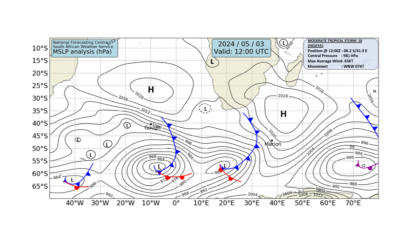
Ernie and Nick, thanks for your replies. I will try to import a smaller portion of the polar map. De facto this one, which is half of the first map I tried;
Also, I noted that cropping images back to much smaller areas help Exp when importing huge parts of the globe. An example is this synoptic map that I cropped back to 30 S 10 E and 50 S 80 E. That worked.
Last edited by Herman_NL (2/14/2023 11:24 am)
- •
- Nick
- Moderator
Offline
- Registered: 9/16/2015
- Posts: 3,181
Re: Polar projection raster image import failed
For sure, a polar stereographic projection is likely to have undefined transformations across the equator. You may be ok is all the reference points are in the southern hemisphere.