
 1 of 1
- MSF68
- Navigator
 Offline
 - Registered: 3/12/2017
- Posts: 9
Great Lakes Surface Analysis and Forcast
Nick,
Weather Data/My Image/NOAA Fax dropdown has information for Atlantic and Pacific oceans (which is awesome.)
Any chance you could include current Surface Analysis and 24/48 hour predictions for the Great Lakes as well?
- us7070
- Admiral
Offline
- Registered: 12/06/2017
- Posts: 279
Re: Great Lakes Surface Analysis and Forcast
NOAA does not (at least as far as i know) distribute weatherfax for the great lakes
but those for the NW Atlantic - from the boston office - do cover the great lakes.
Right now in expedition, the only surface analysis available from that office is the prelininary surface analysis - which doesn't cover as much of the GL as the actual surface analysis - 0Z and 12Z - do
they should probably be added... but they need to be rotated, so maybe that's why they are not there
is there some specific surface analysis or surface forecast for the great lakes that you like?
Last edited by us7070 (3/29/2020 12:35 pm)
- Nick
- Moderator
Offline
- Registered: 9/16/2015
- Posts: 3,396
Re: Great Lakes Surface Analysis and Forcast
Yes, it doesn't yet support rotated images.
- MSF68
- Navigator
Offline
- Registered: 3/12/2017
- Posts: 9
Re: Great Lakes Surface Analysis and Forcast
Mark Thornton has a website (Lakeeriewx.com,) where he displays the current NOAA surface analysis map for the Continental US, as well as 12,36, and 48 hour forecast maps. I have been printing them before the Mackinac races, but it would be cool to be able to load them into Expedition.
Here is the link to the Lake Huron page on that website.
- •
- Ernie M
- Moderator
Offline
- Registered: 11/05/2015
- Posts: 426
Re: Great Lakes Surface Analysis and Forcast
M,
You might try adding the images from Thornton's web site as a geo-referenced image
Tab Charts/Images/import...
His images e.g. Lake Huron Windspeed, although they don't have lat/long they do show data buoys. You can then look up in the NDBC web site for the exact buoy lat/long and use that to geo-reference the image
I used Port Hope KP58 at 44-01 82-48 and Thunder Bay TBIM4 at 45-02 83-12 with pretty good results.
If you keep the name the same i.e. HWM-00, you can update the Exp Image w/o doing the geo-reference over.
BTW in the base image i.e. you can just change the 00 to 12 for the forecast period.
So keep playing with those images and you'll find ways to easily bring them into Exp
Good time to learn new stuff while we're hunkered down!
Ernie
- MSF68
- Navigator
Offline
- Registered: 3/12/2017
- Posts: 9
Re: Great Lakes Surface Analysis and Forcast
Thanks Erie,
I will certainly practice your suggestions.
You're absolutely right -- I'm using all this forced downtime to get better with navigation and Expedition.
Mike
- •
- Nick
- Moderator
Offline
- Registered: 9/16/2015
- Posts: 3,396
Re: Great Lakes Surface Analysis and Forcast
Of course, you can also just download the GLERL grib data
- joshlutton
- Crew
Offline
- Registered: 6/01/2023
- Posts: 2
Re: Great Lakes Surface Analysis and Forcast
Coming on to an old thread...I'm trying to figure out the surface analysis thing for the Great Lakes as well.
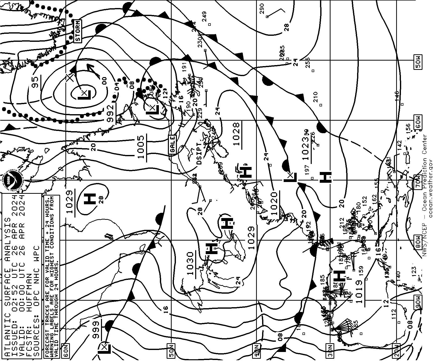
As a broader solution (not just Great Lakes), it would be great to get the WPC conus surface analysis and/or forecasts in Expedition. See
Those are clearly not Mercator projections though. Does anyone have any hints on the settings I could use to import them manually? I've tried a bunch of different settings but haven't found a solution that works. I'm not sure if it is not possible or if I just don't understand projections well enough.
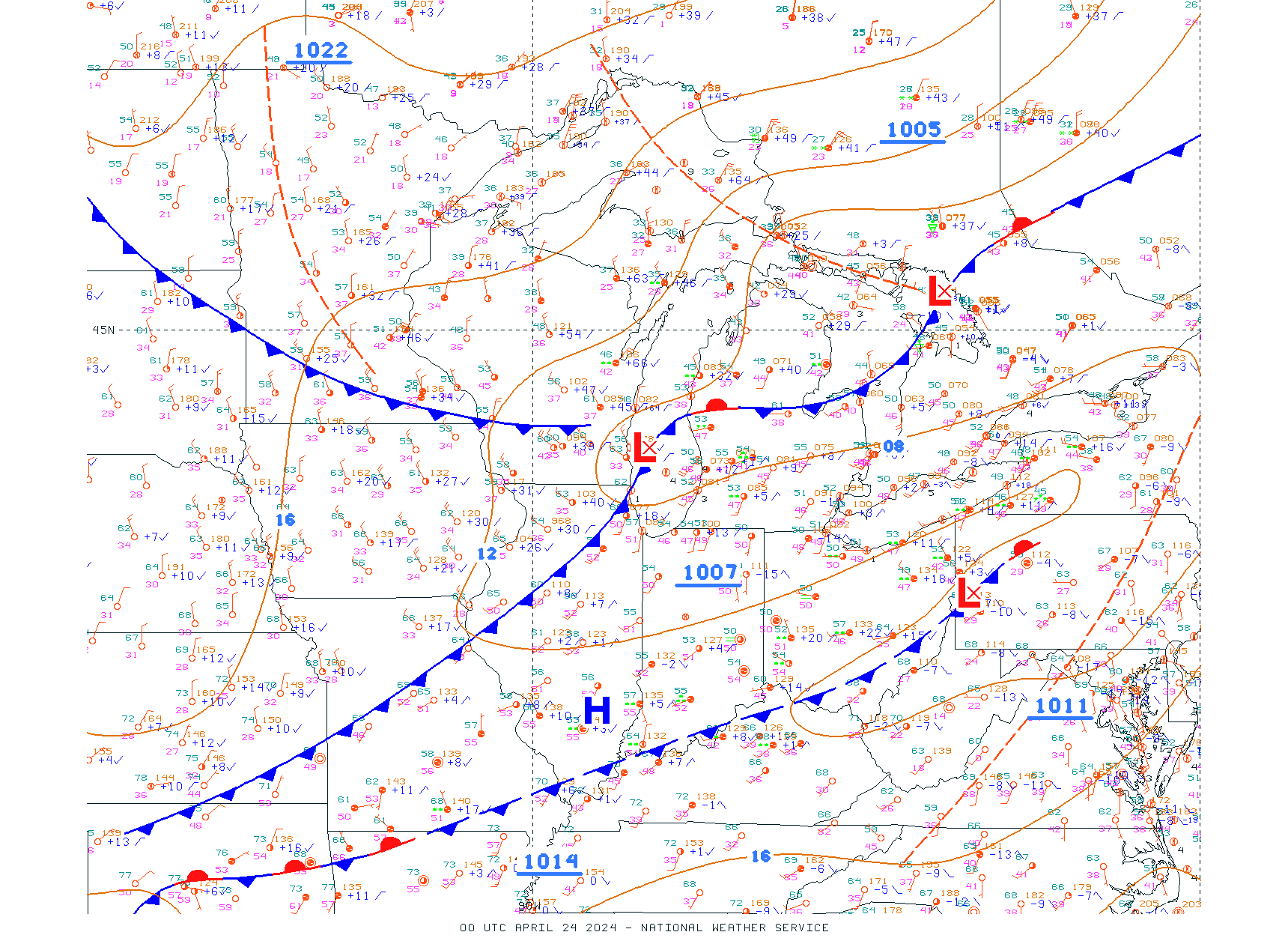
I've successfully imported the OPC's "USA Midwest" surface analysis (see ), which appears to be on a Mercator projection. That would be a cool one to fetch automatically.
Check out RaceData for iOS and Android. Expedition data in the palm of your hand, or on your wrist! RaceData
Interested in advertising here? Over one thousand active navigators and Expedition users visit this forum. Click here to contact the administrator.