 Expedition Navigation Software
  1
1 | General Discussion » FMI Harmonie » 6/29/2024 6:08 am |
- nav
- Replies: 1
-
Hello,
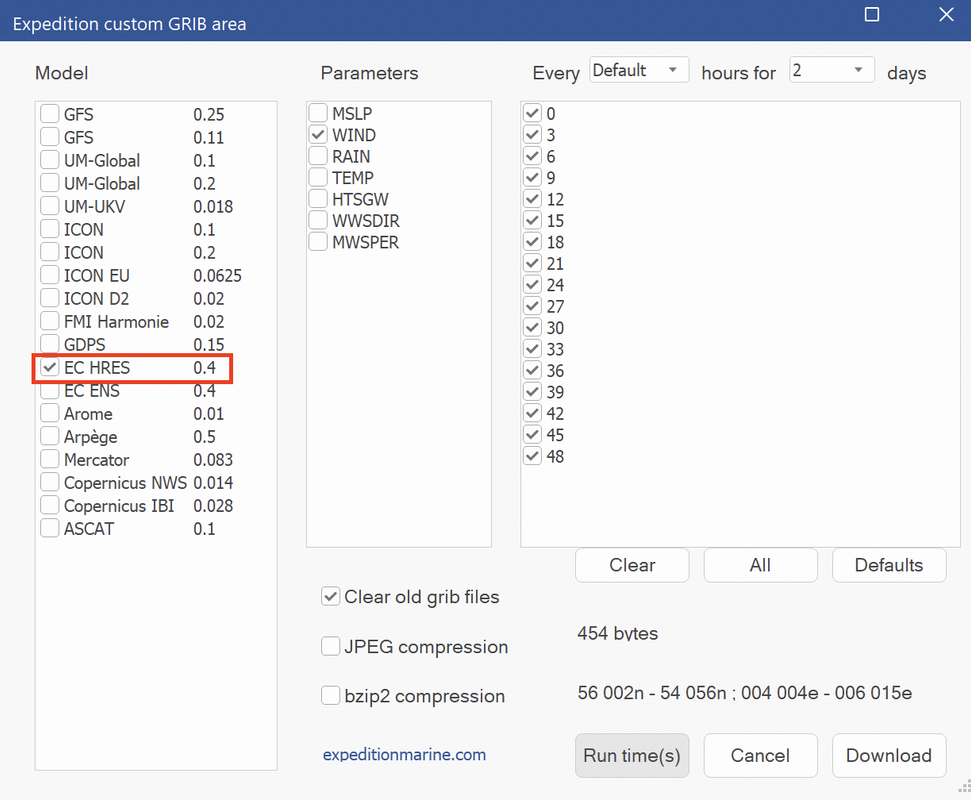
for the Gotland race starting in less than 24h I'd like to download the HigRes FMI Harmonie Model.
However, when I try through Expedition (using 12.0.15) it only downloads pressure and rain but no wind data.
Is there another source where I can get this file easily in grib format for a selected area?
| Suggestions for new features and capabilities » Add "Current Speed" to Colours window » 6/03/2024 11:41 am |
- nav
- Replies: 4
-
...what I mean is a legend, giving a reference for the colours used in the shading.
This is existing with the "Colours"-window, but so far only for "Wind 10m", "Boats", "Race tracking boats", "Ensemble", "Optimal" and "Sails"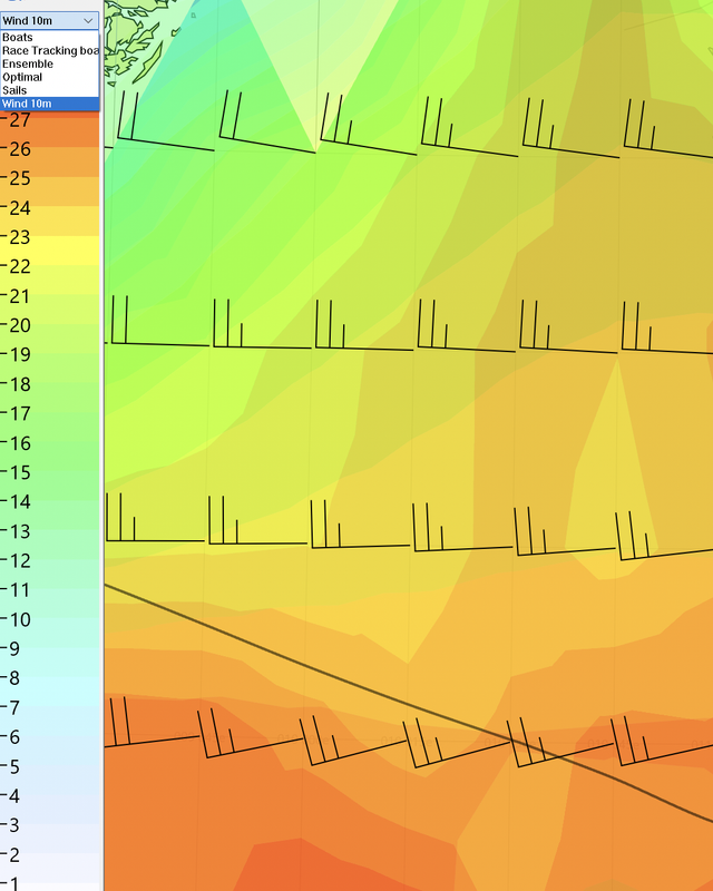
When shading with current or Sig wave height etc. I need to know, wich "Shade/ size max" value I have used in the weather settings in the background. Depending on this input a red colour on the scale could mean anything..
Therefore a colour legend on the side as shown above for wind would be helpful, for a quick overview for myself but also when sharing screenshots with the crew etc.
Of course there's the possibility to display contours (well, at least for the grib file, but not for a routing shading...), but the numbers on the contours are not easy to read, so again a legend would help for a better overview.
| Suggestions for new features and capabilities » Add "Current Speed" to Colours window » 6/03/2024 1:19 am |
- nav
- Replies: 4
-
Thinking a bit more about it it would also be nice to have a colour scale for wave height selectable in the colour legend.
| Suggestions for new features and capabilities » Add "Current Speed" to Colours window » 5/28/2024 11:22 pm |
- nav
- Replies: 4
-
Right now its possible to show a colour legend of "Wind 10m" in the Colours Window.
It would be nice to have the same for current speed, to have a reference when using current speed colour shading on the chart.
| Software Releases » Grib server update » 5/16/2024 3:34 am |
- nav
- Replies: 7
-
Hi Nick,
thank, understood! It's all there already.
One additional comment:
Right now the name of the downloaded Expedition grib file is
EX_Model_resolution_date_download time
for example:
EX_GFS_011_16May24_132659
EX_EC_HRES_04_16May24_095147
What do you think about adding the model analysis UTC time to this name?
so for example
EX_Model_resolution_date_analysis time_download time
That would allow to easily see which model has a newer analysis time without having to cross check the availability table
| Software Releases » Grib server update » 5/16/2024 12:05 am |
- nav
- Replies: 7
-
What are the update times for the EC HRES?
When I download a 10day forecast: is the full forecast available immediately? Or does it start with a forecast for the first few days early in the day and then the longer forecasts become available throughout the day?
I noticed that for example when I download a 10day forecast at 8am UTC it just goes to about 3 days into the future.
When I select "previous run" it downloads 10 days into the future - but that's obvioulsy the run from the day before.
Would it be possible to integrate an info panel in Expedition showing the update times for different weather models / which model can be downloaded right now / when the next model will be available together with the max available forecast range for the specific model?
| Suggestions for new features and capabilities » Expedition Start - feature request for additional start numbers » 5/07/2024 10:17 am |
- nav
- Replies: 1
-
Hello,
…
I have a number of feature requests for the start box:
1) Right now there exist the number box variables "StTmToP" & "StTmToS" for time to port end and time to starboard end and also "P burn" and S burn" with the corresponding time burns to both ends. Where P burn is "StTmToP" minus "Time to gun" etc.
However, for "PortTurnL", "PortTurnR", "StbdTurnL" and "StbdTurnR", there are only the 'time to line' variables available in the number boxes but not the burn ones. It would be great to have a "PortTurnL burn", calculated by taking "PortTurnL" minus "Time to gun" etc.
Or is there a plan to publish a version with user defined variables in the near future, where one could calculate these variables by himself?
2) Below is a screenshot from a typical situation during a reaching start.
The TWD is almost parallel to the line, the boat killing time upwind on starboard tack.
While I can see my time (burn) to the ends and at the current HDG I don't know, where I'd end up when bearing down to the line at a reaching angle.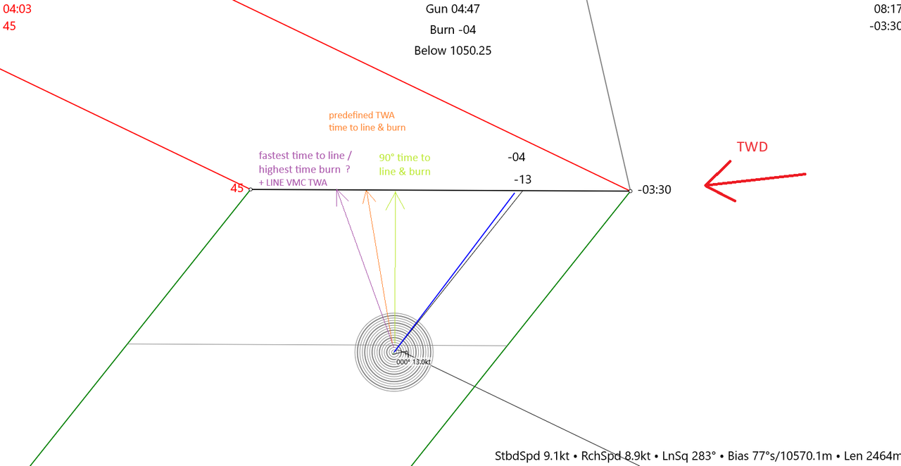
Only after bearing down I can see the time burn for the current course I'm sailing.
But of course I want have know this info before making the call to bear down to the line.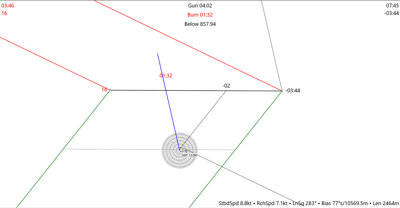
So I think it would be super handy to have this extra information available:
1) fastest time to line (+ corresponding burn), so kind of a 'line VMC time (burn)", together with the corresponding TWA (that one only as number box channel).
2) time (+ corresponding burn) when sailing perpendicular towards the line. (this number will be useless for upwind starts)
3) time (+ corresponding burn) for a preselected TWA that needs to be entered in an extra input field. So while still upwind killing time one could calculate a "XXX" TWA approach time to the line.
All to be selectable / deselectable for display in the start box graphic but also available as number channel
| Questions about Expedition features » Routing for complicated environments and short time scales » 3/25/2024 8:47 am |
- nav
- Replies: 7
-
It also makes sense to draw race notes over land areas and select "avoid in optimal routing" instead of using the "avoid land feature" as routings will run a lot quicker then.
| Software Releases » Grib server update » 3/24/2024 1:26 pm |
- nav
- Replies: 7
-
In the download menu the resolution for ECMWF HRES is still named "0.4"
| General Discussion » SHOM or Proudman Tides for routing analysis. » 11/17/2023 7:13 am |
- nav
- Replies: 1
-
Hello,
I'd like to carry out a statistical routing analysis for the Fastnet race for the past 10years considering not only wind but also current.
For wind I'm going to use the Copernicus reanalysis grib files. That's all straight forward.
For current I intent to use SHOM or Proudman tides (unless there's an even better way(?) ). So far I don't have a subscription, so before doing that I'd like to understand a few things.
1) Are both (Proudman and SHOM) usable in Expedition? On the Expedition website under sales I only find SHOM tidal currents for "Northern and Western France"
2) If both are usable: What is the difference between them? Is there one model considered to be "better"?
3) How far do the models rach back into the past? Is it possible to use them for routings for the past 10years?
4) And now the tricky one:
I expect that the SHOM / proudman models use different tidal coefficients for different dates, so the strength of the current in a certain area will vary over the tidal cycles.
While I can offset the starting time of the multi-year routings to always have the same relation to high tide like on Fastnet starting day (by offsetting the routing starting times by for example one tidal cylce / 12h 25min) and thereby getting at least the right current direction this would however lead to varying current strengths depending on the varying tidal coefficient.
So ist there any way to use the "fixed" current of the 2025 Fastnet with its tidal coefficient for all the routings with the weather from the past 10 years?