 Expedition Navigation Software
  1 of 1
| Questions about Expedition features » (routing) Starting between XX:00 and YY:00 » 9/27/2020 2:44 am |
- Steph753
- Replies: 2
-
Hi
(I still don't have Expedition Navigation Software. These are questions before purchase)
It seems that this feature exists on Adrena Software but I'm starting to prefer to buy Expedition Navigation Software :
Can I indicate a route to Expedition Navigation Software (some waypoints, from A to B) and ask «my starting is between 08:00am and 06:00pm», then the software calculate many routing each 30 minutes (configurable) and finally show me an sheet with a line each 30 minutes and in columns :
- departure time
- travel time
- arriving time
- GWS max
- GWS min
- GWS average
- AWS max
- AWS min
- AWS average
- maybe AWA average (or other something like this to know if most of the time will be Close-hauled or Beam-Reach or Broad-Reach)
- wave height max
- wave height min
- wave height average
- CAPE max
- CAPE min
- CAPE average
- maybe duration of engine use during the trip (if I choose not to dot 100% sailing)
So in few seconds I can decide when I prefer to do my departure.
(much more efficient than manually routing every X minutes ... every time a new GRIB arrives! ... Actually I do this and it's not quite pleasant)
Does Expedition Navigation Software offer this feature?
Thanks for your answer :-)
| Questions about Expedition features » Polar and drift » 9/25/2020 2:10 am |
- Steph753
- Replies: 2
-
Hi
…
(I haven't purchased Expedition Navigation Software yet. I still have some questions.)
When I watch some polars diagrams , I see few lines on a same graph, depending TWA/TWS/SOG (hypothesis there is no tide). OK, but ....
For each TWA/TWS, the difference between COG and HEADING is not the same : drift.
(drift more important if wind (AWA) from side than TWA=170°... but not only...)
And TWA depend of the axis of the boat (so TWA depend of HEADING).
So, when Heading=0°, COG=6°, TWA=x , TWS=y, Bearing to Waypoint = 0°, SOG=10kts, it's not true to make a polar with SOG=10kts : Approach speed to waypoint (VMC) is a trigonometric result of 10kts (I didn't calculate but it's easy).
My first question :
Is Expedition Navigation Software calculate polars from VMC or directly to SOG ? I fear ("fear" ??) the drift is not considered, so in this hypothesis only TWA/TWS/SOG/Heading would be considered.... so polars are not exact.
My second question :
If heeling increase too much, drift increase too. So VMC decrease (SOG can be constant or "not enough"). I read that Expedition Navigation Software have "advanced polar", is this software considering heeling (so drift, so vmc, so....) ?
My third question :
Can Expedition Navigation Software display (feature) "Beat heel" ? (I think is not very important if the software display "beat COG and Perf%" but maybe yes...)
My fourth question :
(I almost forgot). Adrena software can calculate polars in realtime (I don't know regarding my two previous questions). Is Expedition Navigation software calculate and improve polars in realtime ?
Waves (height and direction) and tides are another subject (ok important for diagrams polars but another subject).
Thanks for your answers.
(sorry again for my bad English)
| Questions about Expedition features » Advanced WindPlot » 9/24/2020 1:52 pm |
- Steph753
- Replies: 6
-
 Nick wrote:
(...)
It isn't possible to send plots to B&G displays.Then this feature will be on the Expedition Navigation software.
My question is: Does this feature already exist? (I seem to have understood that you are implying "no").
And if the feature doesn't exist, do the developers of the Expedition navigation software read this forum and get inspired by the requests?
| Questions about Expedition features » Advanced WindPlot » 9/24/2020 1:44 pm |
- Steph753
- Replies: 6
-
I don't think there is any particular difficulty for all of this to be displayed on the computer screen.
On the other hand, this subject of "dotted lines" (one or several different simultaneous colors) sent by the software so that it can be displayed on a B&G display, here on the other hand I do not know if the frames are intended for that. This point seems complex to me (but I may be wrong).
| Questions about Expedition features » Advanced WindPlot » 9/24/2020 1:41 pm |
- Steph753
- Replies: 6
-
Nick wrote:
I hadn't thought of that, but it would be trivial to add to the wind plot window.
I think you understood the point: at a quick glance at the windplot graph it is possible to know if the weather forecast is early, or late, or correct, or totally wrong, or underestimated, or overestimated, etc etc.
One could even imagine adding complexity to the WindPlot graph: for example in gray over a large area the GWD & GWS measurement, and in yellow dotted line the weather forecast X, in red dotted line the weather forecast Y, in blue dotted line the forecast weather forecast Z. At a glance you can easily understand what is happening. Saving time and efficiency. Of course, this remains a "decision aid" and not a function that we follow with our eyes closed. But in a situation of great fatigue (and stress? And difficulty in thinking clearly?) This can be an interesting supplement. And as you say, it doesn't seem technically complicated to me to set up such a graphics function.
(sorry for my bad English. I'm French , and google translator help me ;-) )
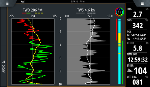
| Questions about Expedition features » Advanced WindPlot » 9/24/2020 9:40 am |
- Steph753
- Replies: 6
-
Hi.
(I have not Expedition Nav Software)
I would like to watch a "WindPlot", something like this with GWD and GWS (or TWS), but with dotted lines that would be the weather forecast (having previously chosen GFS or WRF or other on computer).
Ideally I would like to see this graph outside on a display (B&G? else ?) send by Expedition Nav Software, but at least I would like to see it directly on the computer screen.
Does Expedition Navigation Software offer this feature ?
| General Discussion » Garmin Nautix and Beat COG » 9/23/2020 12:13 am |
- Steph753
- Replies: 5
-
Thank you very much for your answers :-)
| General Discussion » Garmin Nautix and Beat COG » 9/22/2020 3:05 am |
- Steph753
- Replies: 5
-
Hi.
I haven't purchased Expedition Software yet.
I watch the product called GARMIN NAUTIX (ask Google ;-) ) and I imagine that Nautix can show me "Beat TWA" (or "Beat COG") send by Expedition Software.
I know that this function can be sent by Adrena Software to B&G or NKE display.
I think that this function can be sent by Expedition Software to B&G or NKE display.
I saw Expedition Software is partner with Garmin.
So, is Garmin Nautix can display "Beat COG" send by Expedition Software ?
Thanks for your answer
(and sorry for my bad English and possible mistakes....)
1 of 1